Powered by WUFT
Temporarily change filter
Finding your station


Update 11 pm Thursday: The Tropical Storm Warning in effect for most coastal areas of the Florida Panhandle was extended farther east to include Florida’s Big Bend and Nature Coast. Locations now under the warning include Steinhatchee, Cedar Key and Yankeetown. There were no other significant chances to the forecast track, intensity or potential hazards from the National Hurricane Center in their late-evening update.
Hurricane Hunters are investigating an area of low pressure in the Gulf of Mexico this evening that will likely become a tropical or subtropical storm by Friday, then head toward Florida this weekend.
A Storm Surge Warning has been issued from Indian Pass to Clearwater Beach, where an inundation of water up to five feet above normally dry ground is possible. This is an upgrade to the Storm Surge Watch issued by the National Hurricane Center earlier in the day for the same areas.
Floridians should not presume the worst conditions will occur where they see a forecast track.
A Tropical Storm Warning was issued Thursday from the Alabama state line to Florida’s Big Bend. A Tropical Storm Watch was also issued farther south along the Nature Coast to Cedar Key. Within the next 48 hours, tropical storm conditions are likely in the warned areas, and possible in the areas under a watch.
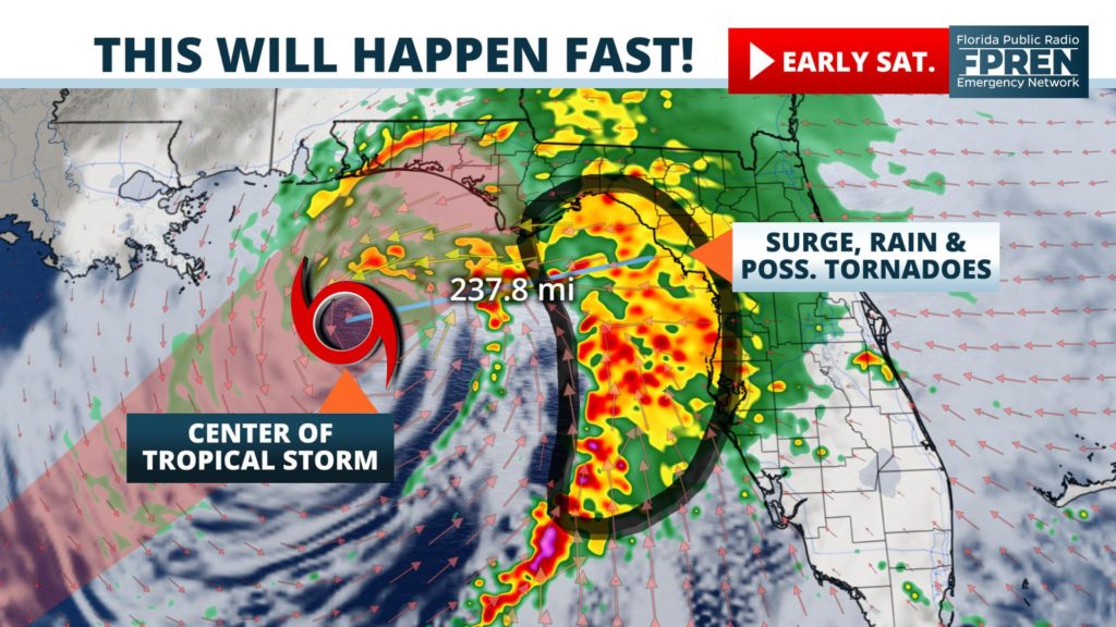
The National Hurricane Center initiated advisories on Potential Tropical Cyclone Sixteen Thursday morning, and forecasters expect it to make landfall in the Florida Panhandle early Saturday. By then, it will likely become the season’s fourteenth named storm and acquire the name Nestor.
As of 8 pm Thursday, Potential Tropical Cyclone Sixteen (or PTC Sixteen) was located 555 miles southwest of the mouth of the Mississippi River and moving northeast at 9 mph. Maximum sustained winds were estimated to be around 40 mph, but the Air Force Reserve hurricane hunters have not found enough tropical characteristics, namely a low-level center of circulation, to classify PTC Sixteen as a tropical storm. However, forecasters have increased the probability of tropical or subtropical development to 90 percent by Saturday.
Upper level winds are likely to steer PTC Sixteen quickly to the northeast in the coming days, where warm sea surface temperatures could allow for further organization and strengthening. However, those same winds are also expected to produce wind shear that could limit the extent of intensification before it reaches land. Most of the reliable forecast models are in agreement that, at the very least, tropical storm conditions will occur in the warned areas regardless of PTC Sixteen’s official classification or strength.
This tropical system will not exhibit the traditional characteristics of a traditional storm or hurricane. The potential impacts, although not as severe, will likely spread far from the storm’s likely path. Therefore, Floridians should not presume the worst conditions will occur where they see a forecast track. In fact, the highest storm surge levels and greatest tornado risk could occur more than 100 miles from the storm’s center of circulation.
The first periods of rain could arrive along portions of the Emerald and Nature Coasts by Friday afternoon or early evening. A more widespread area of rain is likely to develop and move farther inland overnight, generally expanding in coverage to include most of the Florida Panhandle and north-central Florida by Saturday morning.
Meteorologist Megan Borowski put this map animation together earlier Thursday that includes a look at Future Radar.
Current forecast data suggests the heaviest bands of rain will set up somewhere between Panama City and Cedar Key as the center of Invest 96 nears the coast Saturday afternoon. The system is then likely to move swiftly to the northeast, resulting in a gradual reduction in rainfall intensity and coverage by Sunday morning.
The timing of the rain over a weekend may be disappointing to some, but many Floridians will welcome it. A moderate drought has developed over the past few months along the I-10 corridor, which is actually where some of the heaviest rain may occur.
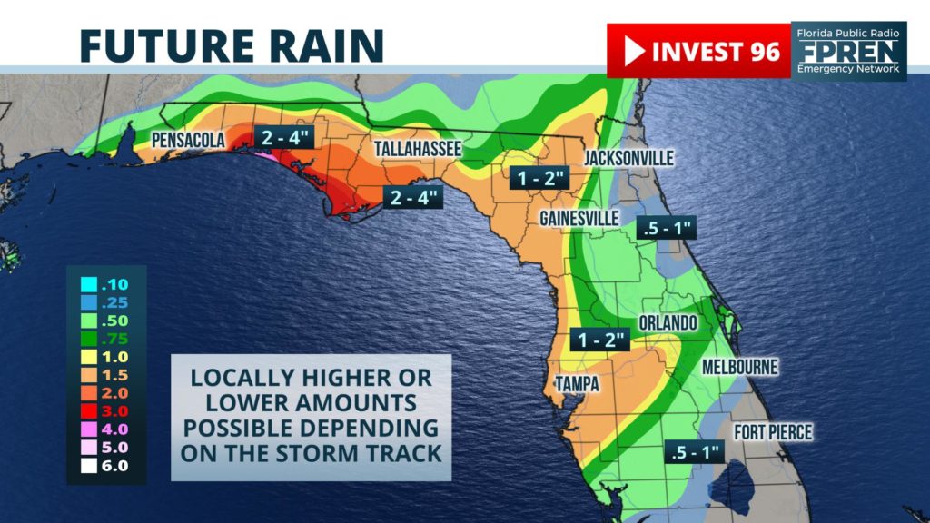
Current forecast data suggests 2 to 4 inches of rain could fall in the Panhandle, with locally higher amounts up to five inches possible. Some of the rainfall accumulations could come over a short period of time, making flash flooding possible, especially in poorly drained and low lying areas.
Potential Tropical Cyclone Sixteen is expected to grow into a very large storm, potentially producing a significant storm surge where the onshore winds will be most persistent.
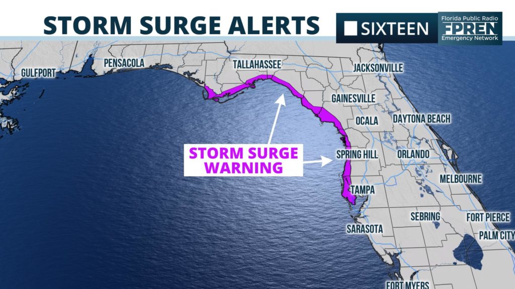
The National Hurricane Center says a storm surge inundation of three to five feet above normally dry ground is possible from Indian Pass to Crystal River. A storm surge of 2 to 4 feet is possible from Homasassa to Clearwater Beach. This doesn’t mean the water will rise to those level in all coastal areas. Surge levels can vary greatly over short distances due to relative timing of the surge and the tidal cycle.
Potential Tropical Cyclone Sixteen will likely create enough spin to produce a few tornadoes where thunderstorms develop in some of the rain bands. Current data suggests this is most likely to occur late Saturday across a large area of the peninsula.
Forecasters at the Storm Prediction Center in Normal, Oklahoma have placed much of central and northern Florida in a “marginal risk” of tornadoes, noting that an upgrade to the risk may be necessary as the more details on the storm’s strength and track become clearer from the National Hurricane Center.
Meteorologists at the Florida Public Radio Emergency Network will continue to monitor this system and provided updates as necessary. We encourage all Floridians to stay informed and set up alerts for your area in our Florida Storms app, available for both iOS and Android phones and tablets.
1885 Stadium Road
PO Box 118405
Gainesville, FL 32611
(352) 392-5551
A service of WUFT at the University of Florida College of Journalism and Communications


Partners of the Florida Public Radio Emergency Network include: Florida's Division of Emergency Management, WDNA (Miami), WFIT (Melbourne), WMFE (Orlando), WFSU (Tallahassee), WGCU (Fort Myers), WJCT (Jacksonville), WKGC (Panama City), WLRN (Miami), WMNF (Tampa-Sarasota), WQCS (Fort Pierce), WUFT (Gainesville-Ocala), WUSF (Tampa), WUWF (Pensacola) and Florida Public Media.
This page uses the Google Privacy Policy and UF's Privacy Policy
